1/5


Hiking Slovakia - Tourist Map
1K+下载次数
31MB大小
3.0.10(26-03-2022)最新版本

详情评价版本信息
1/5
Hiking Slovakia - Tourist Map介绍
涵盖斯洛伐克地区的徒步旅行应用程序。每个徒步旅行者的必备品。
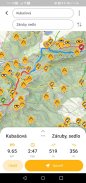
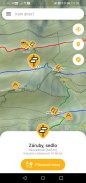
• 所有标记的远足径和路口
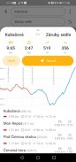
• 带有海拔剖面和行程的路线规划器
• 包含山峰、观景点、野餐或露营地、城堡、洞穴、水源、避难所或住宿的大型数据库
• 带有比例尺的高程图和等高线图
• 能够将地图下载到手机并离线使用
• 当前位置的指示
• 在路标和其他兴趣点中搜索
• 缩小时查看山脉
• 指南针
警告:如果您喜欢迷路,喜欢肾上腺素和生存,请不要使用此应用程序...... ;-)
该应用程序使用来自 freemap.sk 和 openstreetmap.org 的免费数据
Hiking Slovakia - Tourist Map - 版本3.0.10
(26-03-2022)新特性Fixed missing map tiles on old AndroidsFixed importing POIs and routes on low-memory phones

Hiking Slovakia - Tourist Map - APK信息
APK版本: 3.0.10程序包: sk.archae.hiking.android名称: Hiking Slovakia - Tourist Map大小: 31 MB下载次数: 34版本: 3.0.10发布日期: 2024-05-30 19:20:49最小屏幕: SMALL支持的CPU:
程序包ID: sk.archae.hiking.androidSHA1签名: 4E:C3:1D:BD:EA:B8:A0:08:D0:C3:F7:C9:84:A4:27:21:E2:DA:1A:8D开发商 (CN): 组织 (O): GeoEmpires本地 (L): Bratislava国家/地区 (C): SK州/市 (ST): 程序包ID: sk.archae.hiking.androidSHA1签名: 4E:C3:1D:BD:EA:B8:A0:08:D0:C3:F7:C9:84:A4:27:21:E2:DA:1A:8D开发商 (CN): 组织 (O): GeoEmpires本地 (L): Bratislava国家/地区 (C): SK州/市 (ST):
Hiking Slovakia - Tourist Map的最新版本
3.0.10
26/3/202234 下载次数16.5 MB 大小
其他版本
3.0.9
26/3/202234 下载次数16.5 MB 大小
2.3
27/1/202134 下载次数4.5 MB 大小
1.8
3/3/202034 下载次数4.5 MB 大小
1.7.4
13/12/202234 下载次数6.5 MB 大小


同类应用


English


